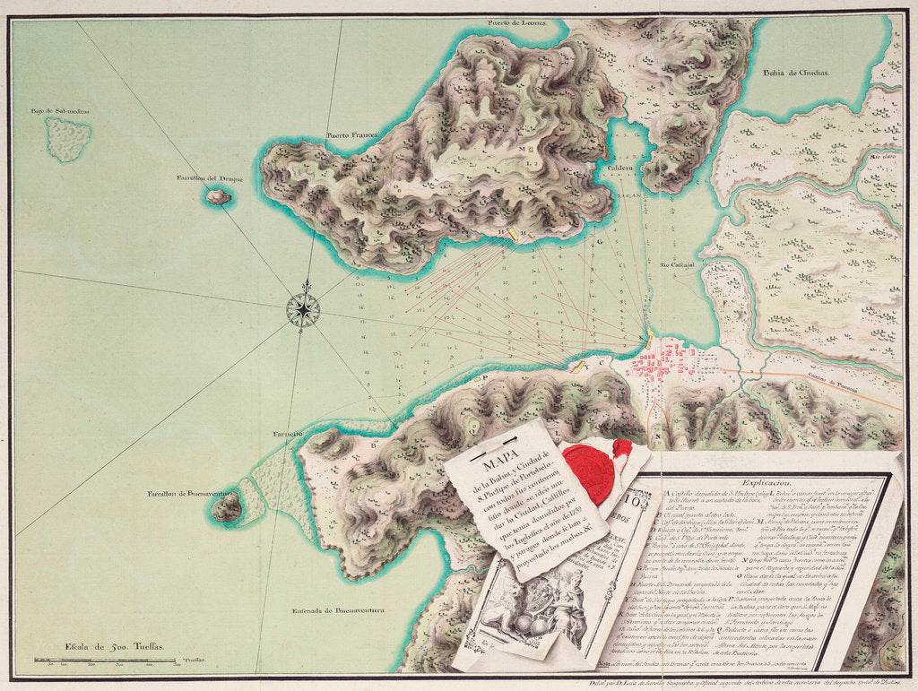
Map of the bay and city of S. Phelipe de Portobelo


Sizing information
| Overall size (inc frame) | x cm ( x in) |
| Depth | cm (in) |
| Artwork | x cm ( x in) |
| Border (mount) |
cm
top/bottom
(in)
cm left/right (in) |
| The paper size of our wall art shipped from the US is sized to the nearest inch. | |

Map of the bay and city of S. Phelipe de Portobelo
'Mapa de la Bahia y Ciudad de S.Phelipe de Portobelo'. Bound sheet. Col. ms. Scale: [ca. 1:14 000]. Cartographic Note: North at eight degrees. Lines of soundings across the bay. Scale in tuesses. Additional Places: Panama. Contents Note: Fortifications shown with their lines of fire. Trompe d'oeil title and key cartouche.
Luis de Surville
- Image reference: F1997
- National Maritime Museum, Greenwich, London
Discover more
More by this artist
Explore the collection
Search for similar images
Product images of Map of the bay and city of S. Phelipe de Portobelo


Our framed prints
Every framed picture is created by hand in our workshop by specialist framers.
Black, white, brown, silver, gold or natural frames available, supplied ready to hang.
All our frames have a smooth satin finish, and measure 20mm (front face) by 23mm (depth from wall).
Read more about our framed art prints.
Manufactured in the UK
All products are printed in the UK, using the latest digital presses and a giclée printmaking process.
We only use premium branded inks, and colours are independently verified to last between 100 and 200 years.
Delivery & returns
We print everything to order so delivery times may vary but all framed pictures are despatched within 5-7 days via courier or recorded mail.
Due to the coronovirus pandemic and Brexit situation, current shipping times may be longer, particularly for destinations outside the UK.
Delivery to the UK is £10 for a single framed print.
We will happily replace your order if everything isn’t 100% perfect.