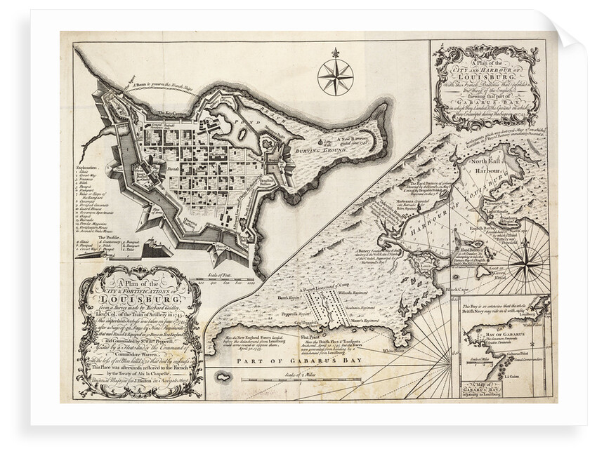
A plan of the city and harbour of Louisburg, Cape Breton

Image information
Sizing information
| Overall size (inc frame) | x cm ( x in) |
| Depth | cm (in) |
| Artwork | x cm ( x in) |
| Border (mount) |
cm
top/bottom
(in)
cm left/right (in) |
| The paper size of our wall art shipped from the US is sized to the nearest inch. | |

A plan of the city and harbour of Louisburg, Cape Breton
With the French batteries that defended it, and those of the English, shewing that part of Garbarus Bay in which they landed & the ground on which they encamped during the siege in 1745. The French built the fortress of Louisburg 1720-1740. The action in 1745 was to stop French privateers from Gabarus Bay preying on New England Grand Banks fishermen. The 1748 Treaty of Aix la Chapelle returned the fortress to the French in exchange for Madras.
J. Hinton
- Image reference: F0383
- National Maritime Museum, Greenwich, London
Discover more
More by this artist
Explore the collection
Search for similar images
Product images of A plan of the city and harbour of Louisburg, Cape Breton


Our prints
We use a 240gsm fine art paper and premium branded inks to create the perfect reproduction.
Our expertise and use of high-quality materials means that our print colours are independently verified to last between 100 and 200 years.
Read more about our fine art prints.
Manufactured in the UK
All products are printed in the UK, using the latest digital presses and a giclée printmaking process.
We only use premium branded inks, and colours are independently verified to last between 100 and 200 years.
Delivery & returns
We print everything to order so delivery times may vary but all unframed prints are despatched within 2-4 days via courier or recorded mail.
Due to the coronovirus pandemic and Brexit situation, current shipping times may be longer, particularly for destinations outside the UK.
Delivery to the UK is £5 for an unframed print of any size.
We will happily replace your order if everything isn’t 100% perfect.