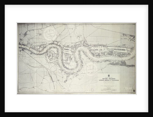
Map of Hampton Court, Kingston and Norbiton


Image information
Sizing information
| Overall size (inc frame) | x cm ( x in) |
| Depth | cm (in) |
| Artwork | x cm ( x in) |
| Border (mount) |
cm
top/bottom
(in)
cm left/right (in) |
| The paper size of our wall art shipped from the US is sized to the nearest inch. | |

Map of Hampton Court, Kingston and Norbiton
Sheet from 'An exact survey of the cities of London and Westminster, the Borough of Southwark, with the country near ten miles round'. John Rocque came to England as a child with his French Huguenot family. He was an estate surveyor and garden designer before he began mapping towns.
John Rocque
Original size: 510 mm x 670 mm
- Image reference: K1142
- National Maritime Museum, Greenwich, London
Discover more
More by this artist
Explore the collection
Search for similar images
Product images of Map of Hampton Court, Kingston and Norbiton


Our framed prints
Every framed picture is created by hand in our workshop by specialist framers.
Black, white, brown, silver, gold or natural frames available, supplied ready to hang.
All our frames have a smooth satin finish, and measure 20mm (front face) by 23mm (depth from wall).
Read more about our framed art prints.
Manufactured in the UK
All products are printed in the UK, using the latest digital presses and a giclée printmaking process.
We only use premium branded inks, and colours are independently verified to last between 100 and 200 years.
Delivery & returns
We print everything to order so delivery times may vary but all framed pictures are despatched within 5-7 days via courier or recorded mail.
Due to the coronovirus pandemic and Brexit situation, current shipping times may be longer, particularly for destinations outside the UK.
Delivery to the UK is £10 for a single framed print.
We will happily replace your order if everything isn’t 100% perfect.