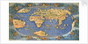


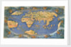

Planisphere world map by Francesco Rosselli, around 1508

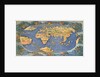
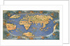
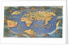
Image information
Sizing information
| Overall size (inc frame) | x cm ( x in) |
| Depth | cm (in) |
| Artwork | x cm ( x in) |
| Border (mount) |
cm
top/bottom
(in)
cm left/right (in) |
| The paper size of our wall art shipped from the US is sized to the nearest inch. | |

Planisphere world map by Francesco Rosselli, around 1508
The dating of this planisphere and sea-chart depends partly upon the fact that the names given by Columbus during his fourth voyage to features in Central America, including Hispaniola and Cuba, are here shown on the Indo-China coast. This is consistent with Columbus's own belief that he had reached the coasts of Asia. This style of world map originated with Ptolemy and continued into the 17th century.
Two world maps on the same mount, probably orginally a double page from a book, laid down inside a brown leather cover and heavily hand coloured (the colouring is so heavy it was long thought to be a manuscript, in fact a method employed by contemporaries to make prints look less like prints). This is the earliest extant map to show the world in 360 degrees of longitude and 180 degrees of latitude within an oval projection, a form which would be adopted by many major cartographers later in the century. Columbus' place names for central America are placed (as claimed by Columbus) along the coast of Asia, which extends to the eastward following the Ptolemaic conception of the continent, into a peninsular North America.
The main issue for cartographers in the early sixteenth century was how to reconcile the Ptolemaic understanding of world geography with the geographical knowledge which reached Europe following the turn of the century voyages of exploration. This map is Rosselli's attempt at that feat, incorporating the latest information into a Renaissance geographical tradition. It is particularly important because it is the only extant world map by a contemporary cartographer to depict Columbus's own understanding of the geographical results of his fourth voyage.
- Image reference: C4568-A
- National Maritime Museum, Greenwich, London
Discover more
More by this artist
Explore the collection
Search for similar images
Product images of Planisphere world map by Francesco Rosselli, around 1508


Our prints
We use a 240gsm fine art paper and premium branded inks to create the perfect reproduction.
Our expertise and use of high-quality materials means that our print colours are independently verified to last between 100 and 200 years.
Read more about our fine art prints.
Manufactured in the UK
All products are printed in the UK, using the latest digital presses and a giclée printmaking process.
We only use premium branded inks, and colours are independently verified to last between 100 and 200 years.
Delivery & returns
We print everything to order so delivery times may vary but all unframed prints are despatched within 2-4 days via courier or recorded mail.
Due to the coronovirus pandemic and Brexit situation, current shipping times may be longer, particularly for destinations outside the UK.
Delivery to the UK is £5 for an unframed print of any size.
We will happily replace your order if everything isn’t 100% perfect.