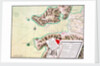

S. Phelipe de Porto Bello
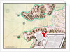


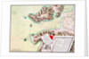
Image information
Sizing information
| Overall size (inc frame) | x cm ( x in) |
| Depth | cm (in) |
| Artwork | x cm ( x in) |
| Border (mount) |
cm
top/bottom
(in)
cm left/right (in) |
| The paper size of our wall art shipped from the US is sized to the nearest inch. | |

S. Phelipe de Porto Bello
This is one of the fourteen exquisite manuscript charts illustrating a report on the defences of Spanish-held ports and anchorages in Central and South America. De Surville was Deputy of the Archives of the Office of the Indies. He added flourishes to his cartography by drawing titles, descriptive lists ad decorative features to look as if they are separate documents lying on, or even pinned to, the page. This chart of Porto Bello shows the fortifications destroyed by the English in 1739, the current systems of defence and proposals for future works.Luis de Surville
- Image reference: C4627_2
- National Maritime Museum, Greenwich, London
Discover more
More by this artist
Explore the collection
Search for similar images
Product images of S. Phelipe de Porto Bello


Our prints
We use a 240gsm fine art paper and premium branded inks to create the perfect reproduction.
Our expertise and use of high-quality materials means that our print colours are independently verified to last between 100 and 200 years.
Read more about our fine art prints.
Manufactured in the UK
All products are printed in the UK, using the latest digital presses and a giclée printmaking process.
We only use premium branded inks, and colours are independently verified to last between 100 and 200 years.
Delivery & returns
We print everything to order so delivery times may vary but all unframed prints are despatched within 2-4 days via courier or recorded mail.
Due to the coronovirus pandemic and Brexit situation, current shipping times may be longer, particularly for destinations outside the UK.
Delivery to the UK is £5 for an unframed print of any size.
We will happily replace your order if everything isn’t 100% perfect.