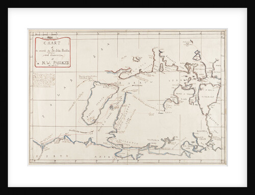


Hydrographical chart of the Arctic regions
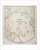

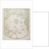
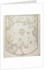
Image information
Sizing information
| Overall size (inc frame) | x cm ( x in) |
| Depth | cm (in) |
| Artwork | x cm ( x in) |
| Border (mount) |
cm
top/bottom
(in)
cm left/right (in) |
| The paper size of our wall art shipped from the US is sized to the nearest inch. | |

Hydrographical chart of the Arctic regions
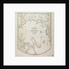
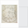
Hydrographical chart of the Arctic regions including the late discoveries of Captain Ross and some original surveys. William Scoresby drew this chart after John Ross returned from his 1818 voyage in search of a North-West passage. Ross reported that his route through Lancaster Sound was blocked by a range of mountains that he saw ahead but Scoresby's chart does not close off the sound entirely.
Object number: G282:1/8
Date: 1820
Original dimensions: 490 mm x 430 mm
- Image reference: F9898
- National Maritime Museum, Greenwich, London
Discover more
More by this artist
Explore the collection
Search for similar images
Product images of Hydrographical chart of the Arctic regions


Our framed prints
Every framed picture is created by hand in our workshop by specialist framers.
Black, white, brown, silver, gold or natural frames available, supplied ready to hang.
All our frames have a smooth satin finish, and measure 20mm (front face) by 23mm (depth from wall).
Read more about our framed art prints.
Manufactured in the UK
All products are printed in the UK, using the latest digital presses and a giclée printmaking process.
We only use premium branded inks, and colours are independently verified to last between 100 and 200 years.
Delivery & returns
We print everything to order so delivery times may vary but all framed pictures are despatched within 5-7 days via courier or recorded mail.
Due to the coronovirus pandemic and Brexit situation, current shipping times may be longer, particularly for destinations outside the UK.
Delivery to the UK is £10 for a single framed print.
We will happily replace your order if everything isn’t 100% perfect.