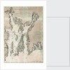
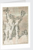

Chart of Ipswich Bay and Cape Ann, Atlantic coast of North America

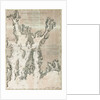
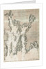
Image information
Sizing information
| Overall size (inc frame) | x cm ( x in) |
| Depth | cm (in) |
| Artwork | x cm ( x in) |
| Border (mount) |
cm
top/bottom
(in)
cm left/right (in) |
| The paper size of our wall art shipped from the US is sized to the nearest inch. | |

Chart of Ipswich Bay and Cape Ann, Atlantic coast of North America
The Atlantic Neptune is a magnificent four-volume atlas of sea charts and views of the east coast of North America, published during the American Revolutionary War by Joseph Frederick Wallet Des Barres (1722-1824). The atlas spans from the St. Lawrence River and Nova Scotia, to Florida and the Gulf of Mexico. One volume also includes Havana and ports in Jamaica. The four volumes were completed between 1777 and 1781, though sheets were published individually as early as 1774.J.F.W. Des BarresOriginal size: 530 mm x 750 mm
- Image reference: K0699
- National Maritime Museum, Greenwich, London
Discover more
More by this artist
Explore the collections
Search for similar images
Product images of Chart of Ipswich Bay and Cape Ann, Atlantic coast of North America


Our prints
We use a 240gsm fine art paper and premium branded inks to create the perfect reproduction.
Our expertise and use of high-quality materials means that our print colours are independently verified to last between 100 and 200 years.
Read more about our fine art prints.
Manufactured in the UK
All products are printed in the UK, using the latest digital presses and a giclée printmaking process.
We only use premium branded inks, and colours are independently verified to last between 100 and 200 years.
Delivery & returns
We print everything to order so delivery times may vary but all unframed prints are despatched within 2-4 days via courier or recorded mail.
Due to the coronovirus pandemic and Brexit situation, current shipping times may be longer, particularly for destinations outside the UK.
Delivery to the UK is £5 for an unframed print of any size.
We will happily replace your order if everything isn’t 100% perfect.