Skip to main content
10% off your first order
☰ Menu
Basket icon
Wishlist icon
0
Account icon
Search icon
Search icon
Inspiration
Collections
Astrophotography
Battles and wars at sea
Children's
Exploration
Graphic designs
Greenwich
Historic figures
Historic vessels
Maps and charts
Photography
Pirates
Seascapes
Time and space
Natural history
World travel
Ship plans
Art gifts
Cushions
Notebooks
Journals
Gift cards
Contact
Contact us
Newsletter
Search art & photography
Search icon
Atlas prints
Showing 1 to 48 of 74
Search these images +
Search Atlas images
The East Indiaman 'Atlas'
William John Huggins
'Atlas' (1782)
Unknown
Atlas (fl.1802)
unknown
Atlas (fl.1802)
Unknown
Le Grand Atlas, ou Cosmographie Blauiane
Joan Blaeu
World map from the Blaeu Atlas, 17th century
John Blaeu
'Atlas' (1782); 'Glory' (1788)
Unknown
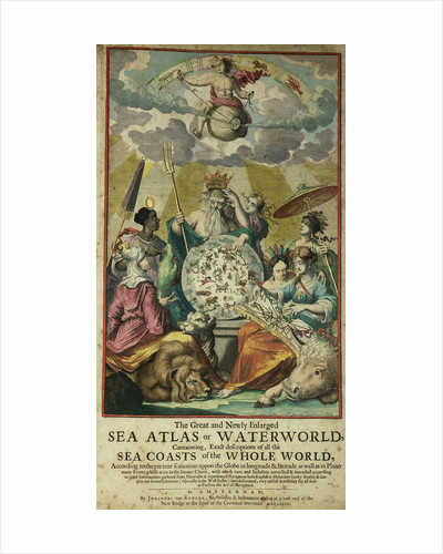
'Great and Newly Enlarged Sea Atlas' or Waterworld, 1682
Jan Luyken
Map of Europe from the Blaeu Atlas, 17th century
John Blaeu
Map of Asia from the Blaeu Atlas, 1662-1665
unknown
Map of Asia from the Bleau Atlas, 1662-65
unknown
A chart bound in van Keulen's 'Great and Newly Enlarged Sea Atlas'...
Johannes Van Keulen
Part of a southern hemisphere star chart from Reiner Ottens's Atlas Maior...
Reiner Otten
Atlantic coasts of Europe and west Mediterranean
Angelo de Conte Freducci
Oval planisphere of the world showing Magellan's track, 1554
Battista Agnese
Planesphaeri Coelestis Hemisphaerium Meridionale
Carel Allard
World map by John Seller, 1675
John Seller
Map of Scandinavia, 1554
Battista Agnese
Chart of Sicily, 1554
Battista Agnese
A map of the city and port of Tripoli in Barbary
John Seller
Chart of Chius (Chios, Greece), 1554
Battista Agnese
Planesphaerii Coelestis Hemisphaerium Septentrionale
Carel Allard
A new mappe of the sea coasts of England, France and Holland,...
John Seller
Chart of Black Sea
Johan B. Agnese
A chart of the easternmost part of the East Indies with all...
John Seller
Chart of Moscow and the Black Sea
Johan B. Agnese
Chart of the Mediterrean, Black and Caspian Seas
unknown
A chart of the sea coasts of England, Flanders and Holland
John Seller
'The Australian Callicéphale'
Hyacinthe de Bougainville
Persia
Battista Agnese
'The Adesmie Épineuse'
Hyacinthe de Bougainville
'The Busseuillie of Botany Bay'
Hyacinthe de Bougainville
'The Australian Flycatcher and the Flycatcher Multicolor'
Hyacinthe de Bougainville
Chart showing discoveries of Ross, Parry and Franklin in the Arctic during...
Thomson
Butterflies, 'The Danaïde Cécile, the Danaïde Anaïs, the Danaïde Edmont and the...
Hyacinthe de Bougainville
Chart of the North Sea and Dutch coast, 1661
Mount & Page
Chart of the Americas
Nikolaus Visscher
Polar projection 'Septentrionalium terrarum' by Mercator
Gerard Mercator
Ormuz-Calicut
Angelo de Conte Freducci
‘Carte du Teatre de la Guerre dans la Pologne, Moscovie & Turquie’...
Pieter Schenk
Chart of the Mediterranean circa 1640
Joan Oliva
Chart showing the Bristol and English Channel
Lucas Jansz Waghenaer
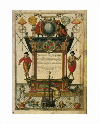
Frontispiece of 'The Mariner's Mirror' (1588) written by Lucas Jansz Waghenaer (1533-1606)
Theodore de Bry
Barranca
William Hack
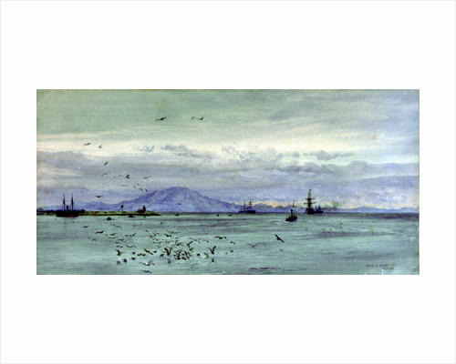
Straits of Gibraltar
William Lionel Wyllie
Angliae, Scotiae, et Hiberniae, sive Britannicar: Insularum descriptio (England, Scotland and Ireland,...
Abraham Ortelius
A description of the sea coastes, of the land of Algarbe, and...
Lucas Janz Waghenaer
The route of the Atlantic Telegraph, The 'Great Eastern' Section of the...
H. Clark
1
2
Next »
Recently viewed
Clear history